Tag: nature photography

  • Piatt Gorge and Raven Rocks: Waterfalls and Heart Rocks

    Piatt Gorge and Raven Rocks: Waterfalls and Heart Rocks


    Axton in a black hat, black jacket, and jeans with his dog in front of a waterfall
    Luna and I at Piatt park

    Today’s hike didn’t go how Cyble and I had envisioned it. Yet, unlike normally when the destination changes and everything’s worse tbis ended up better than I ever expected. I woke up thinking Morgantown was the same distance from Newark as Wheeling and that was a dumbass mistake. Yet, sometimes you win, sometimes you learn. Instead of heading straight to Cooper’s Rock near Morgantown, West Virginia, Cyble and I took a detour that turned into one of the most beautiful, muddy, quiet, awe-inspiring hikes I’ve done in Ohio.

    We drove from Newark to Cambridge, Ohio, and ended up at Piatt Gorge in Woodsfield. From there we went on to Raven Rocks, about 19 miles away in southern Belmont County, and spent the whole day chasing waterfalls, heart rocks, caves, creek crossings, laughs, slips, and exactly zero people.

    Axton in a black hat, black jacket , and jeans sitting on a large rock

    Piatt Gorge: Caves, Waterfalls, and Heart Rocks

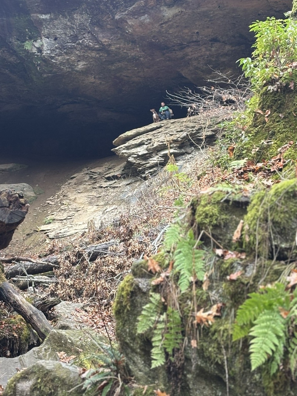
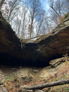
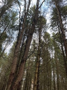
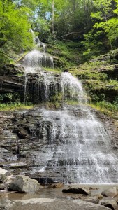
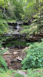
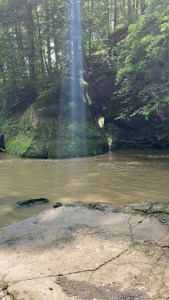
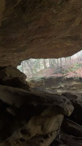
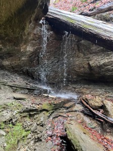
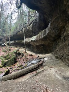
    Piatt Gorge was incredible. The trail loops through rich hardwood forest, switchbacks, and rock shelves. We took the west side trail through a massive cave-like passage that opens up into a waterfall. Waterfalls were everywhere: some roaring, some trickling, some dry even though it was raining. Every waterfall was perfect for photos, and some spots looked swimmable, though I didn’t see any signs saying you could or couldn’t.

    Two falls flowing into eachother at Piatt park
    Double falls at Piatt park

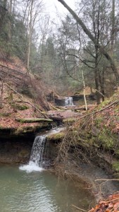
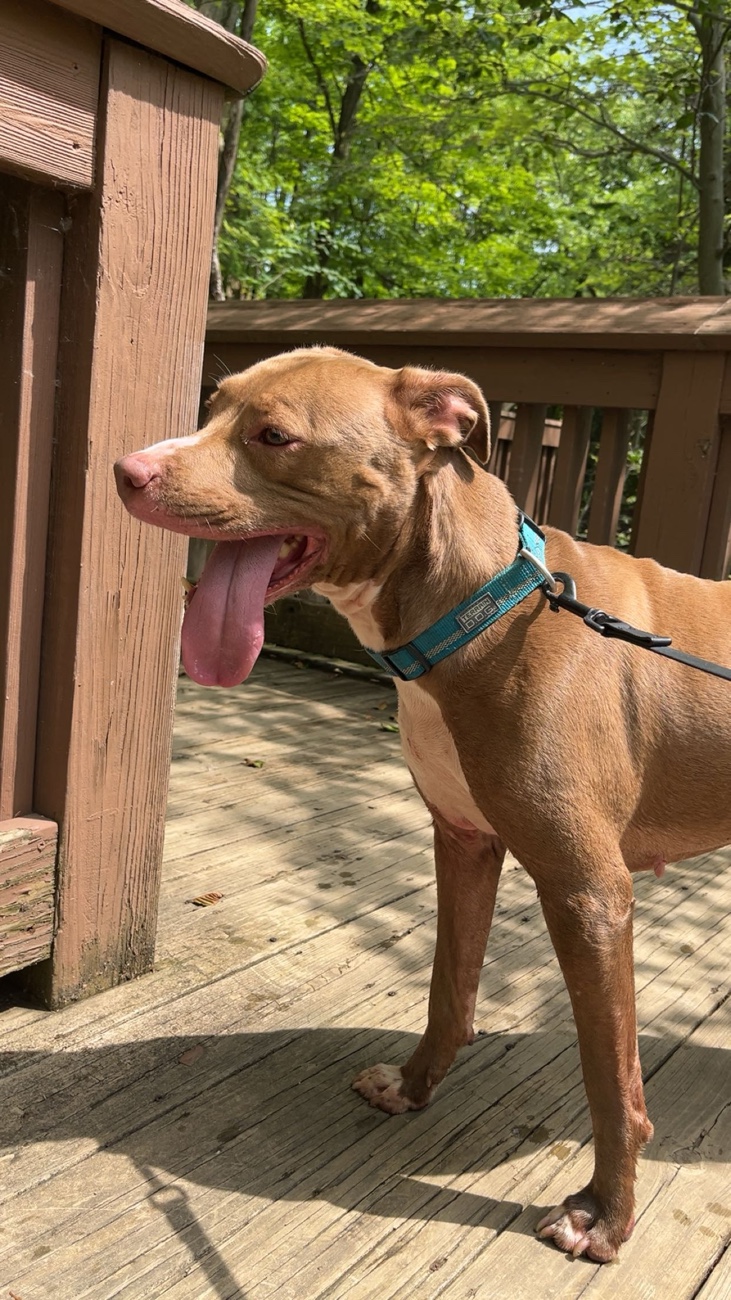
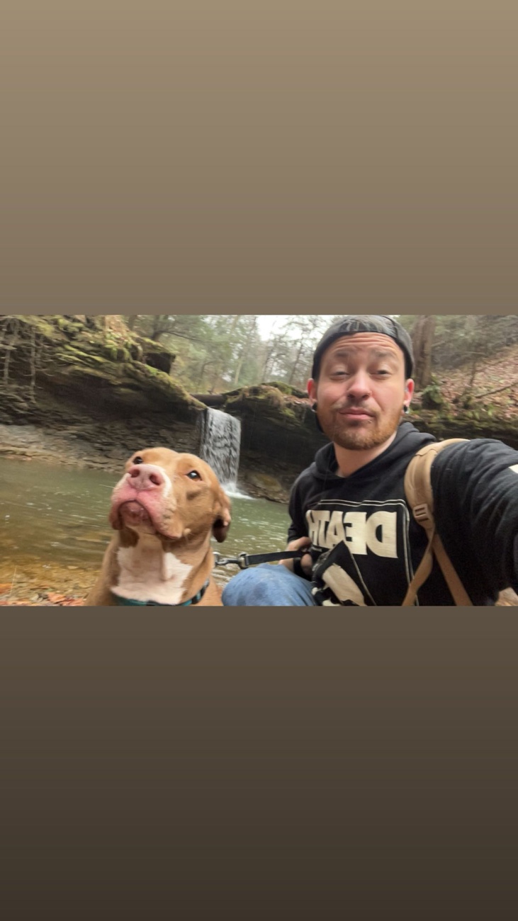
    I had both Luna and Cyble with me and they got all the views, all the rocks, all the laughs. I fell twice, didn’t get hurt, and got some hilarious photos. At one point I collected two heart rocks at the same spot and gave them to Cyble for her and her boyfriend Hunter. I brought home twenty-four little heart rocks, I photographed one huge heart rock big enough for five people to sit on, another large one under a waterfall that I left because it was too poetic, two orange slabs with red and black stripes, two cool conglomerates, and some other orangey stones I liked. Six of these went straight onto my altar.

    Photo from inside cave at Piatt park
    Inside a cave at Piatt park

    The trail was wet and muddy with a few creek crossings. It’s kid- and dog-friendly, but some cliffy sections will pose situations where help for kids and others may be needed. Benches are scattered along the path, but it’s not ADA accessible. Shoes that can handle mud are a must.

    Another fall at Piatt park
    Another fall at Piatt Park

    Planning a day trip from Newark, to Cambridge, or nearby Ohio towns? Piatt Gorge is perfect for waterfalls, caves, and heart rocks. Grab a friend, your dog, a camera, and some waterproof shoes. You’ll want to take your time and explore the cave and waterfall sections.


    What’s your favorite Ohio cliff or fall?

    Tell us in the comments!


    Raven Rocks: Cliffs, New Signs, and Quiet Trails

    Cliff waterfalls at ravens rocks in Ohio
    Cliff falls at raven rocks preserve

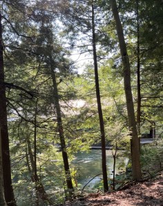
    Next, we went to Raven Rocks nature preserve in Beallsville, Ohio, which is open to the public but privately owned. The 0.4-mile loop at the trailhead drops into ravines with sandstone cliffs and small waterfalls. There are new wooden steps replacing the old ones and trail signs now that weren’t there last time I visited. The place was quiet with no one else around, giving a sense of being completely immersed in nature.

    Raven rocks scenery photo with streams and fall leaves
    Scenery photo at Ravens rocks

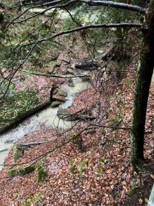
    Trails were wet and muddy, with some creek crossings and cliffy areas that need attention if you’re bringing kids. Dogs are allowed and Luna’s energy made the hike even better. We picked up some garbage in the parking lot and carried it to the bins. Please remember to respect the trails.


    Cooper’s Rock: The Classic Dream

    Though we didn’t make it there today, Cooper’s Rock near Morgantown, WV, still calls to me. It has miles of trails, overlooks of the Cheat River Canyon, and rock formations that make for epic hiking and photography. After today, I’m even more excited to return.


    Trail Notes and Tips

    Trails in these locations are muddy and slick after rain, so wear shoes you don’t care about. Creek crossings are simple but need attention. Kid- and dog-friendly doesn’t mean easy, cliff areas need supervision. Pack out trash and respect private property. Every fall, every splash, every heart rock, and every waterfall is part of the experience.


    So tell me what do you collect on your trail adventures?


    Axton holdings up a nice sized heart shaped rock with a treeline view behind it
    Heart shaped rocks call to me

    Today’s hike exceeded expectations. Piatt Gorge and Raven Rocks are beautiful, challenging, and unforgettable. Share this with someone you want to explore these trails with. You’ll get laughs, muddy shoes, incredible photos, and the quiet magic that only hidden Ohio trails can offer.


    Two other epic Ohio hikes: Hike hike


    Poeaxtry links

  • Hiking Salt Fork: A Cave, A Summit, And a Quiet Mind

    Hiking Salt Fork: A Cave, A Summit, And a Quiet Mind

    Planning the hike:

    Man in jeans a hat and a green shirt and his red nosed American pitbull terrier dog onto of a rock in Hosak’s cave.
    Luna and I in Hosak’s Cave

    We set out pretty early considering we got off work at 6am. I left my house and headed to pick up Sky and The baby shortly after 12 noon. We had been planning three hikes. The Hosak’s Cave Trail to warm up. Then Morgan’s Knob Loop for waterfalls and a summit. Finally finishing up with Stone House Loop to walk through history. By the time we came down from Knob loop, though, the sky was reaching beyond dusk. The pine trees formed a tunnel of shadows, and there was no way we could safely complete the third trail. Considering our lack of headlamps and the baby in tow.. we left it. But what we did finish the cave, the climb, and the peace felt like more than enough.

    Exploring the Cave

    Climbing into Hosak’s Cave was like slipping into another world. We ignored the “trail ends here” signs. Well Luna and I did at least. We then pushed past rough sandstone walls, slipped on loose dirt way to high up, and then found a seat up there too tucked just under the cave’s roof. I sat there for a long moment. I felt the rock beneath me, the forest breathing just beyond the cave’s mouth, and the drip of water somewhere i couldn’t quite see. It felt sacred, strong, feral. It was like the stone held stories just for me. It reminded me of Red River Gorge, but quieter, deeper, soaked in stillness.

    The mouth of Hosak’s Cave in Salt Fork State Park Ohio November 2025
    Hosak’s cave

    Morgan’s Knob Loop

    Then came Morgan’s Knob. The trail wound through rooted forest, climbing gently, until it opened up into rocky outcroppings. At the top, the wind and the stone told me a few import things. The fists was that this land was older than all of us. It reminded me time does not rush here the way people do. Before I left thought it added that no matter what people who are different belong.

    Morgan’s Knob Loop trail.  trail head sign
    Morgan’s Knob Loop Trail

    Salt Fork State Park: Geology and Geography

    All around us, Salt Fork State Park stretched wide. It’s the largest state park in Ohio. This park covers a massive 20,181 acres roughly of rugged hills, ravines, and ridges.  Its terrain belongs to the unglaciated Allegheny Plateau. Simply put that means the hills and valleys were never flattened by ice. This gives the park its wild, carved feel.  The rock underfoot is sandstone, shale, and siltstone. These formed in ancient layers of Pennsylvanian-age geology.  They eventually erode unevenly over time, forming caves like Hosak’s, cliffs, and even blocks of sandstone that break off and slump down. 

    Salt Licks and Human Use

    The name “Salt Fork” comes from mineral salt springs. The natural licks where animals once gathered.

    Native Americans, including the Wyandot, harvested the salt for food and trade. In the 1800s, settlers drilled wells nearly 450 feet deep to extract brine, which was boiled down into salt for commercial use.

      These salt licks helped shape how the land was used, how people lived, and what wildlife visited.

    History and Local Lore

    Speaking of people, history runs deep here. Kennedy Stone House, built in 1837 from sandstone quarried nearby. Is still standing in the park.  It was built by Benjamin Kennedy, whose family lived there for more than a century.  The house eventually became a museum, preserved by a volunteer group that revived it in the early 2000s.  Local lore suggests Hosak’s Cave was used as a hide-out during the Civil War.  This rocky overhang, as creaky as it looks, has seen more than just hikers.

    Legends and Bigfoot

    If you hike Salt Fork, you’ll find places you wouldn’t expect: meadows, deep forest, ridges, and stream valleys. But there’s also a weird, beautiful piece of legend here. Bigfoot tales swirl through these hills.  According to local reports, more than 36 Bigfoot sightings have been claimed here since the mid‑1980s.  The park even hosts Bigfoot Night Hikes. These hikes are where people walk in the dark, listening, eyes open, hoping for something monstrous and mysterious.  One of the wildest things the park was ranked by USA Today as one of the top “Squatchiest” places in the U.S. 

    The upcoming Eco‑Discovery Center includes a Bigfoot character for environmental education. 

    I for one am totally down for a Bigfoot night hike!

    Native American Stories

    Native American stories, too, speak of the place. According to a geological survey, the Wyandot people used the caves for shelter. They may have harvested salt from the licks.  In certain remote caves, “hominy holes” or pits in the stone used as ovens served as places to bake cornbread.  It’s hard not to feel their presence when you touch those walls.

    Modern Park Activities

    Autumn bars trees, grass covered in fallen leaves, and a lake view
    Salt Fork Lake

    Today, Salt Fork is alive for modern adventurers. There are 14 scenic hiking trails and six bridle paths.  The lake, made when the Salt Fork Dam was built (completed in the late 1960s), spans thousands of acres. The lake offers boating, fishing, and quiet reflection as common in Ohio lake life.  There’s also a nature center, archery range, miniature golf, and a lodge nestled in the woods.  For families, the park runs a gem‑mining station, where kids sift for semi‑precious rocks and fossils. Which we all know kid or not is RIGHT UP MY ALLEY! Geologically, this place is a gem. 

    Personal Reflection

    Walking Salt Fork felt like walking through time. The cave and rocks held ancient stories. The summit whispered of wind, motivation, moss, and manifestation . The forest pulsed with leaves, legends, salt, and shadow. By the time we left, I carried something soft and heavy. As well as a piece of earth, memory, and wonder.o

    A man in jeans, a green shirt, and a backwards hat sits with his American Pitbull Terrier near a stick fort on a Morgan’s Knob loop.
    Luna and I near a stick fort on Morgan’s Knob loop.

    Nature as Meditation

    This hike felt different… refreshing, soul‑cleansing still but different. I didn’t think about deadlines or noise. For once my head was full of only leaves and rocks, trees and quiet hours, quality time with nature instead of running amuck. This hike wasn’t about conquering anything. Today was about listening, slowing, and sitting in spirit. Nature held still for us, and we held still for nature.

    Hiking today felt different for me. I wasn’t pushing for a peak, checking my watch, or rushing to do do do. I was quiet. Listening. Letting rock and leaf and shadow hold me steady for a few hours.When we left, I felt lighter but not less.

    Evergreen trees and Bare fall trees line the entrance and exit to Morgan’s Knob Loop trail
    The Line of trees guarding the trail

    Fracking and Controversy

    Near the edges of Salt Fork State Park, fracking is no longer just a rumor. This is happening and in a way that worries a lot of people. According to WOSU, the first well pad was built just outside the park boundary, and from there, the wells will go deep underground and then horizontally beneath the park’s terrain.  The process involves pumping millions of gallons of water mixed with sand and chemicals into the rock layers to break them apart and release gas. 

    Environmental groups like Save Ohio Parks argue this isn’t compatible with natural, protected land.  These forests are dense, biodiverse, and some experts say they’re second only to the Amazon for ecological richness. The fracking infrastructure could permanently harm the ecosystem. 

    Water is a major concern. Each frack well could use 4 to 10 million gallons of fresh water, according to the advocacy group.  Some of that water could come from local lakes and streams. Yes, even the waters that feed Salt Fork Lake. Which will then return as toxic wastewater.  That wastewater is often radioactive and must be injected deep underground. Thus raising long-term risks. 

    There have also been safety incidents: in January 2025, a well pad roughly five miles from the park had an explosion.  While no injuries or water contamination were reported, the accident only increased community fears.

    On top of that, dozens of environmental and public‑land groups are calling for a moratorium on fracking in Ohio’s parks.  They argue the dangers are not just theoretical. Let’s be real… the land, water, and wildlife here deserve better than industrial extraction.

    From forest fragmentation, constant truck traffic, night‑lighting, and the risk of chemical or wastewater leaks. The opponents say fracking could permanently change the character of Salt Fork.  

    It’s like an addict injecting poison deep into their veins. They continue hoping it stays contained… yet their body, or the earth, doesn’t always cooperate. Pressure builds, tremors come, and what you inject may seep into places you never intended, or imagined.

    Yet here, in the wild heart of Salt Fork, that reckless injection threatens not just the rocks and streams, but the quiet sanctuary that has lasted for millennia.

    All hiking raw media

    Links. Portfolio. Ko-fi. Twitch.

    One hike. Another hike. A different hike?

  • Honey Run Waterfall Hike & Ledges Adventure

    Honey Run Waterfall Hike & Ledges Adventure

    A Sunny Afternoon at Honey Run Waterfall

    This past Tuesday, Luna and I set off for an afternoon hike at Honey Run Waterfall in Knox County, Ohio. We left Licking County around 3 p.m. The sun still high and the temperature sitting comfortably in the low 80s. Pretty perfect hiking weather if you ask me.

    The short trail leading to the falls is shaded and inviting, opening up to the sound of rushing water and sunlight glittering off the rocks. Luna wasted no time running straight into the pool beneath the falls. Of course, I followed her in. The water was cool and clear, a refreshing contrast to the warmth of the day.

    Discovering the Ledges

    After drying off a bit, we continued on the trail that follows the Kokosing River. That is when I found out there were ledges. I had no idea they existed here. Luna and I have been here a few times before. I just have really bad special awareness. Anyway… The rock formations stretched along the riverbank, carved out by years of water and weather. We climbed up and around, exploring ledges and paths that weren’t to hard for Luna. I was soaking in views that felt almost misplaced.

    There’s something about a place like Honey Run. Sure, it is small. Yet somehow it is still full of quiet beauty. Between the falls, the sunlight, and Luna’s joy bouncing from rock to rock. This was one of those hikes that reminds you why getting outside matters.

    Hike Notes

    📍Location: Honey Run Waterfall Park, Knox County, Ohio

    👣Trail Length: Around 1 mile total (moderate terrain)

    🔆Highlights: Waterfall, ledges, Kokosing River views

    🐶Dog Friendly: Yes (leash required)

    🕰️Best Time to Visit: Spring through early fall

    Photo album Portfolio Links

  • Mohican Covered Bridge: Quiet Ending Woodsy Day

    The Covered Bridge at Mohican State Park was the third and final stop of our short morning out. Which happened to be right after I got off work overnight on Sunday, August 3rd. (Which was Saturday nights shift by night math) I wasn’t sure how long we’d actually be out, but it felt like we still had one last stop in us before heading home. The Covered Bridge made the perfect choice.

    Mohican State Forrest covered bridge
    Covered Bridge Mohican

    This one’s a classic, with the wide wooden beams, but different in lacking the old red color. It sports the color black and though faded it feels right. The Clear Fork River flows right underneath. You don’t have to hike to reach it at all… so another for the easily accessible theme. You can just drive right up, park nearby, and walk across or around it. There is a steady calm feeling here. Even with the few people I encountered around. You hear the river. You feel like the trees lean in a little closer.

    Luna and I didn’t take the full trail next to the bridge, just a small part of it. I wanted to get a few side shots of the bridge itself, and Luna was clearly still in an exploring mood. The trail ran alongside the water for a bit, framed with late-summer greenery, and I spotted all kinds of mushrooms just off the path. More than a few bright, orange like those from Blue Rock. A lot popping out from the sides of downed trees like they’d just emerged the battle on top.

    Trees, river , and side view of covered bridge. Photo taken from trail
    Photo of bridge, Forrest, and river taken from trail

     Unexpectedly enough it also felt nostalgic in a way. I was reminded of the covered bridge in Belmont County. The one next to my old high school. We took senior photos and class group shots there, but mostly it was where we snuck off to smoke reefers and escape whatever was going on that day. Seeing a bridge like that again, tucked into the woods out here, hit different. It felt familiar in the best way. Even though this one’s in use and their different colors I welcome the pleasure of a fond memory.

    River view through the trees from the trail
    River view

    This was just one of those slow, winding little forest detours that makes the whole morning feel more complete. We’d already completed the Fire Tower and the Gorge Overlook. This was just the extra bonus. It even reminded me a little of home. I felt relaxed and in my element without the need to rush. Just to feel the forest, with my baby dog who wasn’t quite ready to go home yet. And that’s okay because honestly I never am either.

    All photos from the day

    ko-fi

  • Coming Home from Asheville: Adventures at New River Gorge, Hawk’s Nest, and Waterfalls in the Rain

    Coming Home from Asheville: Adventures at New River Gorge, Hawk’s Nest, and Waterfalls in the Rain

    I left Asheville later than I planned. Originally I wanted to be on the road by 6 AM but, sleep had other plans for me. I didn’t hit the road until 9. Honestly, I didn’t really want to leave. I was already missing Kelsey and Luna like crazy. If it weren’t for them, the drive home wouldn’t be calling.

    Hawk Nest State Park Signage at the overlook
    The New River Gorge Bridge and the Newest WV National Park

    The trip back was full of beautiful views. They motivated me to push my ass home. These views ended up being little adventures in themselves. First on the list was New River Gorge, where the air smelled like fresh pine. I noticed I could smell the rain coming for the first time in years. The Appalachian hardwoods were thick with oak and hickory trees as far as I was able to see. Man, the views over the gorge were breathtaking! The river winding through deep cliffs. I grabbed some stickers to remember the place. Though, the real prize was the silence, and also the mossy rocks laying beneath the towering trees. I visited this place often as a kid. I expected to find it less breathtaking. It was actually more stunning than I recall.

    Axton in the rain at Lover's Leap overlook in a blue t-shirt
    Lovers leap overlook

    Hawk’s Nest was next, and man, the mushroom show there was something else. Orange mushrooms popped like little bursts of flame against the forest floor. I spotted turkey tails layered in their colorful rings, and the chicken of the woods clung to fallen logs. The trees shifted here to include more maples and sycamores, their leaves a full display of green. I wandered some overlooks, feeling the wind and watching clouds dance over the valleys. Lover’s leap is definitely a must-see! I wonder if there’s significance in the name? I got caught in a sudden downpour. It drenched me to the bone as soon as I made it to the leap’s overlook. I love the rain, and I find it refreshing, especially spiritually. The wet rocks and leaves glistened under the gray sky. The sound of water everywhere made it feel like the forest was alive. It was whispering sweet nothings to me.

    Cathedral Falls  Gauley Bridge WV mid summer
    Cathedral falls

    Cathedral Falls was the third stop. It’s the kind of hidden gem you hope for. The water was cascading down carved stone surrounded by ferns and moss thick enough to hide a whole world beneath. The cool mist from the falls was a perfect refresher. It was by far the most crowded place I stopped by size. There may have been fewer people in number. However, 15-20 people in that area made me more uncomfortable than usual.

    The fall known only as little roadside falls less than a mile from Cathedral Falls
    Little roadside wv falls

    The “little roadside fall” right down from Cathedral falls was the perfect punctuation mark on my journey home. The little cascade served as a reminder that nature always has a story to tell. Even if you’re the only one driving past to notice it. Which is what kept me at my last stop for so long. I was the only one there, and it felt meant for me.I’m back now, tired but full, carrying all these moments with me. The plants, the fungi, the waterfalls, the memories all make this place more than just a spot on the map. They’re the pulse of the mountains, the wild heart of Appalachia. They remind me of home, and that I am pure Wild and Wonderful to the bone.

  • You Could Still Beat Us! Hiking Cascades & Old Mill Trail in the Rain

    You Could Still Beat Us! Hiking Cascades & Old Mill Trail in the Rain


    You could still beat us. Maybe. If you’re fast. Or waterproof.

    I Know Not to “Make Precise Plans”

    Yet, I made a whole plan this morning. Mapped everything out. A full-ass waterfall route, organized and optimistic. And then we didn’t follow a single part of it after the first stop. Typical.

    Luna the red-nosed American Pitbill & Axton on the wooden boardwalk at Cascade Falls in Elyria, Ohio
    Cascade Waterfall Elyria Ohio Totally had a hard rain the day before & later that day

    We started at Cascades in Elyria. Real cute, real scenic, real fucking hot. It was already pushing 85 by the time we got there, and the air wasn’t moving at all. Nothing but still heat baking into the rocks and the back of our necks. We were out there trying to appreciate nature while actively evaporating. So we did the reasonable thing. Looked at the rest of the route, looked at each other, and said fuck it. Loop-de-loop detour time.

    We rerouted ourselves straight to Old Mill Trail. I almost called it Old Man Trail out loud, and honestly, I stand by that. It fits. By the time we pulled up, it was about to start raining. It got just steady enough to soak you, just warm enough out that we didn’t care anymore. We were already overheating, so it felt more like a reset than an inconvenience. So we hiked anyway. Me hiding my phone under ,y hat and not my hat hiding my head.

    Huge rocks with trees growing on top on the trail to Cascade Falls
    Part of the creek leading up to Cascade Falls, sun beam in the center, and creek almost out of its bank

    We did both sides of the trail loop. Just about three miles total, maybe a little under, all while completely drenched. The trail was soft and wet but passable, and the creek was running clear. Luna got in the water a couple different times to cool off and honestly I thought about following her. At that point, nothing mattered but staying moving and not slipping on moss.

    The mushrooms were out like they knew it was their time. Bright reds, ghostly whites, slick oranges, clusters and frills and weird little glowing ones tucked into the moss. Some looked poisonous. Some looked like they were made out of coral. All of them looked like they had something to say. We stopped repeatedly. We crouched down to take a picture. Sometimes, we pointed out one that looked like it could bite back.

    Two orange mushrooms grow out of a downed log
    Two cap mushroooms cream colored growing out od a downed log

    It wasn’t the hike we planned, but it’s the one we got. And even soaking wet, even completely off route, it was still a good one. We’ll call it a sweat-to-soak-to-smile kind of day. That’s how summer trail chaos works sometimes. You don’t always beat the heat, but you can at least out-walk it. For a little while, anyway.

    Tree and sky view when I made it back to the car. Drinched

    links Poem hike