Tag: state parks

  • Trekking East Shore Dillon Lake: Slag Glass, Meadows, and Storybook Trails

    Trekking East Shore Dillon Lake: Slag Glass, Meadows, and Storybook Trails


    Best for:

    Nature journal readers, amateur hikers, Ohio or Native American history buffs, families with young explorers, and adventurers seeking a meditative and, easier stroll.

    Dead leaves and dirt form the ground around a wooden sign with a blue bird and the second page of the story
    Part of the story for the Storybook Trail

    A Mid-February Escape to the Woods:

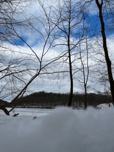
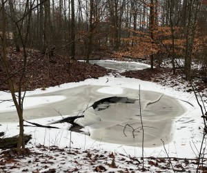
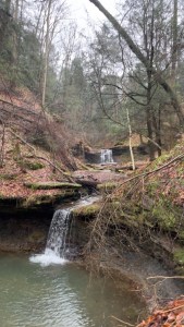
    There is a specific kind of stillness that settles over the Ohio landscape in late winter, and the East Shore of Dillon Lake captures it perfectly. On a recent trek through the Ranger Loop and Storybook Trail, the woods felt like they were holding a secret. That was simply waiting for the first true breath of spring to tell someone.

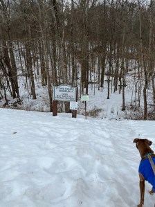
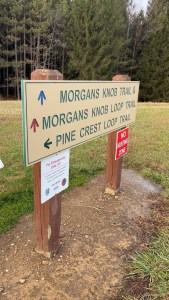
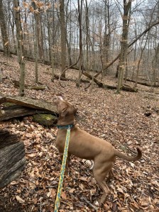
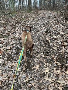
    Accompanied by my dog, Luna, I set out to map roughly two miles of winding paths. Trails at Dillion state Park offer far more than just a workout, bringing a narrative written in the trees and the earth itself.

    Luna the red furred APBT with blue collar and yellow and blue leash stands in the winter foliage of dead leaves surrounded by down or bare trees and moss overs rocks.
    Squirrel!

    The rhythm of the trail is a silent conversation between the soles of your boots and the soul of the woods.

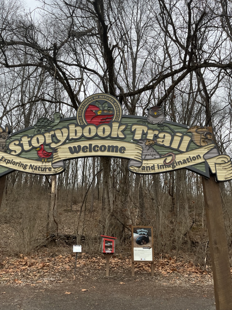
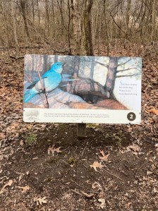
    The Storybook Forest and Lakeside Vistas:

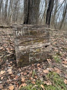
    The journey began on the Storybook Trail, an area that seamlessly blends literature with the outdoors. As we moved through the “Story Forest,” signs tucked among the timber guided us through a localized tale, making the walk feel like stepping into a living child’s book.

    Carved on not legible wooden sign marking where the trail I started off storybook trail was.
    The sign where I veered off the paved trail & onto the dirt trail.

    The Notable Trail Highlights:

    • The Storybook Path: the paved sections at the start and end of the multiple trail path I took to form a loop. This part of the trail highly accessible or nice for a gentle warm-up.
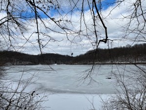
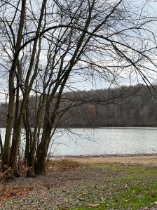
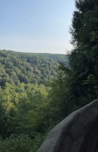
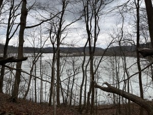
    • Lakefront Gazing: Frequent breaks in the treeline reveal sweeping views of Dillon Lake’s blue-grey waters.
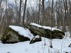
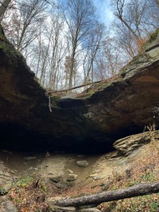
    • Ancient Bedrock: The trail skirts exposures of Black Hand Sandstone, a 350-million-year-old formation that once near here served as a landmark for Tribal Communities.  
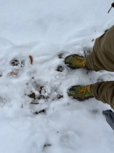
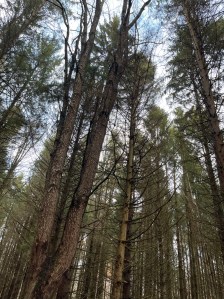
    • The Terrain: A mix of slight inclines and soft forest floors that offer some semichallenging sections for your legs without exhausting the spirit. As well as paved, loose rock, dirt both loose and packed in separate trail sections and some grassy areas.
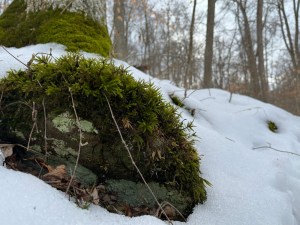
    Turkey tail mushroom circle on the front of a downed and sliced tree. Dead leaves fill the rest of the image
    My kind of fairy circle.

    Shimmering Finds:

    The true highlight of the Ranger Loop appeared as we veered from pavement to forest trail. Pieces of what looked to be rock in many areas sparkled with unexpected colors. Scattered throughout the trail and edges of the pavement where soil holds fragments of teal, blue, green, and purple slag glass.

    The Slag Glass Trail:

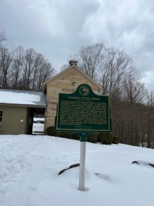
    While these look like fallen stars, they are actually beautiful remnants of the region’s industrial past. In the early 1800s, Moses Dillon (the park’s namesake and builder of Zanesville’s famous Y-Bridge) established one of the world’s largest iron foundries right in this valley. This “glass” is the byproduct of that iron smelting process. Which was a vibrant reminder of the foundry fires that once lit up the Licking River valley

    Axton’s pale palm containing 9 slag glass pieces in an array of different shades of blue, green, and purple.
    Jackpot?

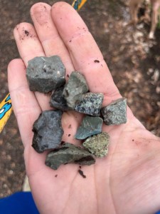
    The sun hits the candy colored glass and meets my eyes. I’m reminded, of the industrial history of a time not too long ago.

    Join the Conversation:

    I’d love to hear about your local hidden gems!

    Have you ever stumbled upon “industrial artifacts” like slag glass while out on a trail?

    Or, if you’ve hiked Dillon Lake, which loop is your personal favorite for finding a bit of solitude?

    Let me know in the comments if you prefer your trails paved and predictable or wild and glassstrewn

    I look forward to reading anything you have to say or add to this.

    View of Dillon Lake through the winter leaf bare trees, foothills in the back dead leaves and winter foliage cover the forest trail.
    Lake view.

    To walk these hills is to trace the fingerprints of iron-masters and ancient travelers alike.

    Every mile walked is a stanza written in your personal journal of the Great Outdoors.

    Echoes of the Licking River

    Before the U.S. Army Corps of Engineers completed the Dillon Dam in 1961 for flood control, this area was a bustling hub of transportation and trade. From the ancient Adena people who built the nearby Nashport Mound.

    Or

    The mid19th century canal and railroad workers, these two miles of trail have seen centuries of movement. Walking here one 57 minutes and two-mile loop visit at a time or more, still you can’t help but feel the weight of that history underfoot.

    Luna the APBT, In a blue collar with a yellow and blue leash walks in the dead leaves on a trail through leafless trees in the winter woods.
    Luna, daddy’s pretty babyyyy.

    Thoughts from the East Shore

    Dillon Lake State Park continues to be a sanctuary for those of us who find our creative spark in the dirt and the shade. Between the nostalgic charm of the Storybook Trail and the surprising vibrance of the slag glass on the trail, the East Shore Ranger Loop is a reminder that beauty is often found in the small, shimmering details beneath our feet.

    Whether you’re here for the miles, the minerals, or the memories of Moses Dillon’s iron works, this trail offers a peaceful reset for the busy mind.

    Initials, names, hearts, shapes, and other things carved into the bark of a tree centered with bare trees in the background.
    As poetic, symbolic, and beautiful yet dystopian this may be, it is also very harmful to the tree. While you may say “it’s just me” one quickly turns to many. Then this becomes another dead or dying tree. Practice Leave No Trace in all the things you do.

    Share This Trail Guide:

    If you found this blend of history and hiking helpful, consider sharing it with your favorite outdoor group.

    or

    You could start bookmarking it and other hiking trails for your next Ohio adventure!

    Sharing helps other explorers find these quiet corners of the world and supports the community of creators who document them. 


    Internal Links:


    External Links:

    Poeaxtry’s Links. Portfolio.

    The entire Poeaxtry Store on

    Payhip Featuring:

    Gumroad & Payhip have all Poeaxtry’s digital items, tarot & pendulum readings, freebies, and more.

    Etsy has Poeaxtry’s digital and physical items.


  • Salt Fork Winter Hike: Kennedy Stone House & The Weight of the Land

    Salt Fork Winter Hike: Kennedy Stone House & The Weight of the Land


    Best for:

    History enthusiasts, hiking with dog’s, intermediate hikers looking for semi-rugged terrain, and year-round exploration of Ohio’s landscapes.


    Luna in a blue tshirt surrounded by snow at the trail head
    Sign at the trailhead which is across the road from the parking lot. Make sure you look both ways when you cross.

    A Mid‑Winter Reckoning

    On February 11, 2026, we stopped at Salt Fork on the way home. We found history and nature under a sky whose color was reminiscent of spring time blue, while the sunlight played peek-a-boo with Luna and I. I decided we would take the trail named the stone house loop.

    Like a blessing we were the only ones there. This is a loop that sits just shy of 2 miles on AllTrails, i guess that’s if you don’t include the curious hikers’ wondering steps. My final count was closer to 2.5 miles. The park was transformed by mid‑shin snow drifts and a deceptive layer of melting ice and snow mixed into the layers underfoot. Trail physics and keeping my feet on the ground mattered here more than fast mileage.

    The Lake

    The lake reflected the stark winter quiet in the few places that reached fully thawed. The lake remained mostly frozen, with random thawed spots where the sun’s rays hit during the recent three-day warm spell.

    Ice does not just cover the water; it turns the landscape into a mirror, reflecting the quiet resilience of a forest waiting for the thaw.

    The slide

    Luna moved through the drifts with a canine confidence I couldn’t match even if you paid me. While I navigated the uneven terrain by digging my heel into the snow I placed each step carefully to avoid a full fall. I nearly slipped many times before the final hill pulled me down the majority of its length like a park slide. Which I followed up with a burst of uncontrollable laughter and cold adrenaline. A reminder that winter hiking is as much about surrender as it is about movement.

    Salt fork lake mostly frozen surrounded by the bare winter branches and evergreens with sky’s of blue
    Salt fork lake mostly frozen still.

    The Vertical Timeline

    To walk this ridgeline is to traverse a vertical timeline of human history layered over land made by deep water, salt, and stone.

    Long before the 3,000‑acre lake was dammed in the 1960s, this land was a map of survival. The park’s name comes from the natural mineral springs and salt licks along Salt Fork Creek that brought deer, bison, and people long before written history.

    History is never truly buried; it is simply pressed into the soil, waiting for someone to walk the path and acknowledge the footsteps that came before.

    Native Americans

    Indigenous groups including Paleoindians, followed by Woodland and Mississippian cultures, left their signatures in stone tools, pottery fragments, and trail networks that would echo in the paths we walk today. Shawnee and Delaware people later moved through these hardwood ridges, using salt springs and creek corridors as seasonal food zones and travel routes.

    European Settlers

    By 1830s, the landscape shifted again with European settlement. Benjamin Kennedy purchased land here and chiseled local sandstone into what is now the Kennedy Stone House. Which was constructed from huge native blocks and positioned to be overlooking the lake and hills. The house stayed in the Kennedy family until 1966. Now Stone House sits on the National Register of Historic Places, preserved as a witness to a century of transformation in this valley, and is still used as a museum.

    Khaki pants green,orange, and yellow crocs surrounded by white mostly untouched snow
    Have you ever considered who shared this ground where we stand throughout history?

    Currently

    Standing before it in the snow, the house feels less like a museum and more like a witness to the layers of displacement, ambition, and “progress” that define Ohio’s geography. Time and time again we are reminded of the people and cultures that were destroyed by the European settlers, as we explore Ohio. Please make sure to pay respects to the original people of the land we stand on in this country.


    Salt Fork: Trails & Terrain

    Salt Fork’s beauty is jagged and layered. While the Stone House Loop provides the historical heartbeat, the surrounding acreage offers a deeper, more rugged silence. The park’s trails range from short nature loops to moderate terrain that follows forest ridges, caves, creek valleys, and some higher points overlooking the lake.

    A view of salt fork lake from witching the trees and snow
    A view from the snow, below.

    Other Trails in Salt Fork and Nearby Areas

    • Hosak’s Cave: This isn’t just a “cave” in the casual sense, it’s a sandstone formation sculpted by eons of wind and water, with crevices that hold ice inflows in the cold months. It’s tucked along a short trail that allow you to walk through ancient stone veins.
    • Morgan’s Knob: A quiet hike into higher forest where the wind feels a bit different. In other seasons the summit offers panoramic views of the reservoir and ridges. In winter it becomes a silent cathedral of bare branches, frozen lakeshores, and distant mostly barren ridgelines.
    • Salt Fork Ridge and Bridle Trails: A large group trails that makes up one interconnected single track. Winding through open meadows, steep climbs, and dense woods. A network of trails that mirrors the iconic Ohio terrain beyond this park.

    These trails are living corridors of history and just a few of those contained in Salt Fork. The soils that once held footprints of Indigenous peoples, settlers, and now hikers like us.

    Moss covers a rock surrounded by snow
    I love the contrast winter brings like that of moss and snow.

    Local Additional Day Trip Spots

    • Seneca Lake Park: 12–15 miles south.
      A smaller public park centered around Seneca Lake with wooded paths and shoreline walking. Trails here are shorter and gentler than Salt Fork’s ridges but still offer varied terrain and lake views in all seasons. It’s one of the most accessible local parks for a small companion hike or a secondary stop after Salt Fork.  
    • Wolfe Run State Park: 20-25 miles north. A classic Ohio state park with rugged woodlands. It features a section of the Buckeye Trail plus additional loop paths that dip into forest and around Wolf Run Lake. It’s a solid same-day alternative when you want elevation, trail diversity, and a quiet feel a bit closer to Salt Fork’s type of terrain.  
    • Dillon State Park- 45 miles west.
      A larger state park built around Dillon Reservoir with forested ridge trails, longer trail loops, and scenic overlooks. It has several established hiking options ranging from short nature routes to longer connector trails. Trails hug hardwood hills and bluff edges. This makes it great for a more demanding additional location to make full-day hiking trip either before or after a Salt Fork trail if you are looking for more.  
    Snow surrounds the Kennedy stone house and green historical sign at salt fork
    The Kennedy Stone House Historical Sign.

    The Industrial Shadow

    The peace of Salt Fork is currently caught in a vice. Hiking here you are moving through the Utica Shale region. This is a landscape increasingly defined by extraction as much as it is recreation.

    In January 2025, the Groh well pad near Antrim, less than five miles from the park entrance, exploded and burned for more than half a day before fire crews could bring it under control. State crews closed State Route 22, evacuated nearby homes, and let the fire burn to avoid danger to responders. Thankfully no one was killed, but the explosion became a stark visual manifesto of the risks posed by fracking operations near public lands.

    According to environmental groups, this well pad was part of a site with requirements under an EPA consent decree that included pressure monitoring and corrective action plans. These may not have been timely implemented. Multiple other regional spills and past violations show the ongoing vulnerability of water and soil where oil and gas activity is permitted near wildlife areas.

    When we choose to step into the woods, we become witnesses to the tension between the fragility of the wild and the heavy reach of industry.

    This doesn’t even start to mention the disruptions to wildlife’s natural environment and their health.

    Save Ohio Parks and allied advocates argue against fracking under or adjacent to state parks. This is sending millions of gallons of water mixed with sand and chemicals into deep shale to crack rock and force hydrocarbons to the surface. Fracking is incompatible with protecting the natural and historical legacy of places like Salt Fork.

    Every quiet mile hiked here now feels like an act of quiet protest as much as it does a blessing we may not always get to experience.

    Luna in a blue shirt and Axton in tan khaki pants and a grey jacket outside the Kennedy stone house at saltfork surrounded by snow and green bushes
    Axton and Luna at The Kennedy Stone House.

    The Vibes of the Hike

    This wasn’t just a walk; it was a tactile engagement with history and the elements. Between Luna’s frantic leaps through snow and my own snow‑covered slide, the hike became a story of excitement, effort, and presence. Where snow that still clung mixes with thaw, every footfall feels like a negotiation with earth and water.

    Salt Fork is a living document. From the Indigenous hunters of the mineral licks, the Kennedy family’s masonry, to now the modern threat and aftermath of the Groh well pad explosion. The land carries its scars and its beauty simultaneously. Salt fork left me woke to the precariousness of the wild spaces we have left.

    Moss covers Rocks that are covered with and surrounded by snow. Bare trees and evergreens surround it all.
    What can I say I like rocks.

    Check out my Hosaks Cave trip.

    Find all Poeaxtry links.

    Shop all digital collections, readings, and freebies Gumroad and Payhip.


  • Hiking Sustainably in 2026, Exploring Ohio

    Hiking Sustainably in 2026, Exploring Ohio


    A small frozen pond at Flint Ridge in Licking country ohio. some some holes in the ice, snow dusted woods floor and bare trees
    Frozen Quarry at Flint Ridge filled with rainfall.

    Eco-friendly Hiking Plan

    This year the goal is simple but deliberate, energetic, we hike sustainably where we live first. I take you all virtually to explore Ohio’s state parks, preserves, arboretums, city parks, hidden gems, and more. I will also fold in planned travel to visit my sister in North Carolina. As well as trips back home to West Virginia. I plan to even sprinkle in Pennsylvania, Kentucky, Indiana, and Michigan. I’ll do this in a way that honors the land, reduces my carbon impact, and celebrates the natural world local.

    We’re not waiting to see the world somewhere else. We’re learning to love the world right where we are.


    Why Eco-Friendly Hiking Matters

    Eco-Friendly hiking isn’t about guilt. It’s about intention. It means hiking where you already are and where you’re already going. Instead of planning huge trips that blow your carbon-footprint out of the sustainable realm. It means choosing nearby parks and preserves over flights, embracing city parks, local trails, hidden overlooks, and lake shore paths. And still planning longer multi-state legs when meaningful and reasonable.

    This approach:

    Shrinks the carbon footprint, builds local connection, deepens seasonal awareness, supports local economies, and grows appreciation for everyday nature.


    Axton sit's on the edge of a cliff on Conkles Hollow Rim trail
    Conkles Hollow- Rim Trail

    Some of Ohio’s State Parks, Preserves, and Outdoor Wonders We’re Seeing

    Hocking Hills State Park

    A cornerstone of Ohio hiking with waterfalls, deep rock shelters, winding forest trails, and sandstone ravines. It’s dramatic, popular, and beautiful, but also a reminder that crowds can challenge trails and quiet places alike. Hiking sustainably means going off-peak or seeking the lesser-known corners of the park to spread impact. As well as signing up for permits (they are free for specific areas) to protect the environment.

    Maumee Bay State Park

    Perched on Lake Erie’s shore, this 1,336-acre park offers boardwalk hiking, wetlands, bird watching, fishing, and nature observation. Bonus – No miles of difficult terrain, great for low impact days and water-linked hikes. 

    Highbanks Metro Park

    This park is just north of Columbus with roughly ten trails. It has massive bluffs above the Olentangy River, ancient earthworks, and a nature center. Here you can learn how this all connects to geology and culture. The Perfect place for mindful hikes that meet both history and ecosystem. 

    Kelleys Island State Park

    I may be most excited for this one. Sitting on Lake Erie the island park with six miles of mixed trails, shoreline, habitats, and glacial grooves. This is a place where water meets stone and slow walks deliver unexpected insight. 

    Hidden Nature Preserves like Wahkeena Nature Preserve, with wetlands and orchid habitat, unique fen landscapes, and boardwalk trails. Offering us a lesson in preservation and quiet observation. 

    City and Gateway Gems

    Arboretums, hidden parks, local preserves, and more. Hudson Springs Park with lakes and easy trails. The Holden Arboretum canopy walk, mixing local beauty with accessible low-impact visits. 

    Smaller hidden spots like the Buckeye Trail that spans over 1,400 miles of varied terrain, linking birding routes, marshes, forests, prairies, and beaches right across Ohio. These places work at reminding us that nature doesn’t need to be far. 

    Double Waterfall at Piatt Park - January 2026
    Piatt Park – January 2026 Monroe County, Ohio

    Comment and share ways you already practice Eco-Friendly hiking, or ways you plan to practice them in the coming year! I love to hear from all of you!


    North Carolina

    We’ll hike trails near Asheville and the Blue Ridge parkway. I’ll be prioritizing waterfalls, overlook points and local favorites.

    West Virginia and Pennsylvania Routes

    top level of mount wood overlook and part of the rolling hills view
    Read a poem I wrote here Mount wood Overlook – Wheeling, Wv

    West Virginia’s natural treasures like North Bend State Park provide rail-trail hiking and wooded climbs with minimal emissions per mile.  Nearby Pennsylvania’s Raccoon Creek State Park or Ryerson Station State Park. These offer forested trails that are a short drive from the Ohio border and great for combined adventures. 

    Michigan Days

    Lake shore paths, urban parks and natural dunes, give us water, wind, and open space without long internal flights.


    How We Practice Low-Impact Hiking

    Stay on trail or areas you are allowed to explore. This is to protect flora and soil.

    Always pack in, pack out.

    Try to choose trails near home first.

    Gently Carpool or combine trips.

    Balance rugged hikes with easy preserves.

    Learn local natural history as you hike.

    This isn’t about saying no to travel. It’s about saying yes to responsible adventure that doesn’t erase the places we love.


    A thought as we part….

    This year, I aim to build a map of sustainable footsteps. As well as a collection of Ohio parks, preserves, arboretums, city parks, hidden gems, and eco-friendly travel corridors. These reflect how I plan to see the world without leaving a heavy mark behind. Nature is everywhere. Let’s make sure our footprints are thoughtful.

    A photo of the Big Spring
    Kitch-Iti-Kippi- “Big Cold Spring”

    Share with someone you’d like to practice more Eco-friendly ways to love and see nature with!


    Before you go please consider supporting Eco-friendly hikes, and art work that takes the lead when it counts! Donation are accepted via CashApp, PayPal, Ko-Fi, or Buy Me a Coffee. This helps to keep our projects and community thriving.


    Check out all Poeaxtry Links

  • Hiking Salt Fork: A Cave, A Summit, And a Quiet Mind

    Hiking Salt Fork: A Cave, A Summit, And a Quiet Mind

    Planning the hike:

    Man in jeans a hat and a green shirt and his red nosed American pitbull terrier dog onto of a rock in Hosak’s cave.
    Luna and I in Hosak’s Cave

    We set out pretty early considering we got off work at 6am. I left my house and headed to pick up Sky and The baby shortly after 12 noon. We had been planning three hikes. The Hosak’s Cave Trail to warm up. Then Morgan’s Knob Loop for waterfalls and a summit. Finally finishing up with Stone House Loop to walk through history. By the time we came down from Knob loop, though, the sky was reaching beyond dusk. The pine trees formed a tunnel of shadows, and there was no way we could safely complete the third trail. Considering our lack of headlamps and the baby in tow.. we left it. But what we did finish the cave, the climb, and the peace felt like more than enough.

    Exploring the Cave

    Climbing into Hosak’s Cave was like slipping into another world. We ignored the “trail ends here” signs. Well Luna and I did at least. We then pushed past rough sandstone walls, slipped on loose dirt way to high up, and then found a seat up there too tucked just under the cave’s roof. I sat there for a long moment. I felt the rock beneath me, the forest breathing just beyond the cave’s mouth, and the drip of water somewhere i couldn’t quite see. It felt sacred, strong, feral. It was like the stone held stories just for me. It reminded me of Red River Gorge, but quieter, deeper, soaked in stillness.

    The mouth of Hosak’s Cave in Salt Fork State Park Ohio November 2025
    Hosak’s cave

    Morgan’s Knob Loop

    Then came Morgan’s Knob. The trail wound through rooted forest, climbing gently, until it opened up into rocky outcroppings. At the top, the wind and the stone told me a few import things. The fists was that this land was older than all of us. It reminded me time does not rush here the way people do. Before I left thought it added that no matter what people who are different belong.

    Morgan’s Knob Loop trail.  trail head sign
    Morgan’s Knob Loop Trail

    Salt Fork State Park: Geology and Geography

    All around us, Salt Fork State Park stretched wide. It’s the largest state park in Ohio. This park covers a massive 20,181 acres roughly of rugged hills, ravines, and ridges.  Its terrain belongs to the unglaciated Allegheny Plateau. Simply put that means the hills and valleys were never flattened by ice. This gives the park its wild, carved feel.  The rock underfoot is sandstone, shale, and siltstone. These formed in ancient layers of Pennsylvanian-age geology.  They eventually erode unevenly over time, forming caves like Hosak’s, cliffs, and even blocks of sandstone that break off and slump down. 

    Salt Licks and Human Use

    The name “Salt Fork” comes from mineral salt springs. The natural licks where animals once gathered.

    Native Americans, including the Wyandot, harvested the salt for food and trade. In the 1800s, settlers drilled wells nearly 450 feet deep to extract brine, which was boiled down into salt for commercial use.

      These salt licks helped shape how the land was used, how people lived, and what wildlife visited.

    History and Local Lore

    Speaking of people, history runs deep here. Kennedy Stone House, built in 1837 from sandstone quarried nearby. Is still standing in the park.  It was built by Benjamin Kennedy, whose family lived there for more than a century.  The house eventually became a museum, preserved by a volunteer group that revived it in the early 2000s.  Local lore suggests Hosak’s Cave was used as a hide-out during the Civil War.  This rocky overhang, as creaky as it looks, has seen more than just hikers.

    Legends and Bigfoot

    If you hike Salt Fork, you’ll find places you wouldn’t expect: meadows, deep forest, ridges, and stream valleys. But there’s also a weird, beautiful piece of legend here. Bigfoot tales swirl through these hills.  According to local reports, more than 36 Bigfoot sightings have been claimed here since the mid‑1980s.  The park even hosts Bigfoot Night Hikes. These hikes are where people walk in the dark, listening, eyes open, hoping for something monstrous and mysterious.  One of the wildest things the park was ranked by USA Today as one of the top “Squatchiest” places in the U.S. 

    The upcoming Eco‑Discovery Center includes a Bigfoot character for environmental education. 

    I for one am totally down for a Bigfoot night hike!

    Native American Stories

    Native American stories, too, speak of the place. According to a geological survey, the Wyandot people used the caves for shelter. They may have harvested salt from the licks.  In certain remote caves, “hominy holes” or pits in the stone used as ovens served as places to bake cornbread.  It’s hard not to feel their presence when you touch those walls.

    Modern Park Activities

    Autumn bars trees, grass covered in fallen leaves, and a lake view
    Salt Fork Lake

    Today, Salt Fork is alive for modern adventurers. There are 14 scenic hiking trails and six bridle paths.  The lake, made when the Salt Fork Dam was built (completed in the late 1960s), spans thousands of acres. The lake offers boating, fishing, and quiet reflection as common in Ohio lake life.  There’s also a nature center, archery range, miniature golf, and a lodge nestled in the woods.  For families, the park runs a gem‑mining station, where kids sift for semi‑precious rocks and fossils. Which we all know kid or not is RIGHT UP MY ALLEY! Geologically, this place is a gem. 

    Personal Reflection

    Walking Salt Fork felt like walking through time. The cave and rocks held ancient stories. The summit whispered of wind, motivation, moss, and manifestation . The forest pulsed with leaves, legends, salt, and shadow. By the time we left, I carried something soft and heavy. As well as a piece of earth, memory, and wonder.o

    A man in jeans, a green shirt, and a backwards hat sits with his American Pitbull Terrier near a stick fort on a Morgan’s Knob loop.
    Luna and I near a stick fort on Morgan’s Knob loop.

    Nature as Meditation

    This hike felt different… refreshing, soul‑cleansing still but different. I didn’t think about deadlines or noise. For once my head was full of only leaves and rocks, trees and quiet hours, quality time with nature instead of running amuck. This hike wasn’t about conquering anything. Today was about listening, slowing, and sitting in spirit. Nature held still for us, and we held still for nature.

    Hiking today felt different for me. I wasn’t pushing for a peak, checking my watch, or rushing to do do do. I was quiet. Listening. Letting rock and leaf and shadow hold me steady for a few hours.When we left, I felt lighter but not less.

    Evergreen trees and Bare fall trees line the entrance and exit to Morgan’s Knob Loop trail
    The Line of trees guarding the trail

    Fracking and Controversy

    Near the edges of Salt Fork State Park, fracking is no longer just a rumor. This is happening and in a way that worries a lot of people. According to WOSU, the first well pad was built just outside the park boundary, and from there, the wells will go deep underground and then horizontally beneath the park’s terrain.  The process involves pumping millions of gallons of water mixed with sand and chemicals into the rock layers to break them apart and release gas. 

    Environmental groups like Save Ohio Parks argue this isn’t compatible with natural, protected land.  These forests are dense, biodiverse, and some experts say they’re second only to the Amazon for ecological richness. The fracking infrastructure could permanently harm the ecosystem. 

    Water is a major concern. Each frack well could use 4 to 10 million gallons of fresh water, according to the advocacy group.  Some of that water could come from local lakes and streams. Yes, even the waters that feed Salt Fork Lake. Which will then return as toxic wastewater.  That wastewater is often radioactive and must be injected deep underground. Thus raising long-term risks. 

    There have also been safety incidents: in January 2025, a well pad roughly five miles from the park had an explosion.  While no injuries or water contamination were reported, the accident only increased community fears.

    On top of that, dozens of environmental and public‑land groups are calling for a moratorium on fracking in Ohio’s parks.  They argue the dangers are not just theoretical. Let’s be real… the land, water, and wildlife here deserve better than industrial extraction.

    From forest fragmentation, constant truck traffic, night‑lighting, and the risk of chemical or wastewater leaks. The opponents say fracking could permanently change the character of Salt Fork.  

    It’s like an addict injecting poison deep into their veins. They continue hoping it stays contained… yet their body, or the earth, doesn’t always cooperate. Pressure builds, tremors come, and what you inject may seep into places you never intended, or imagined.

    Yet here, in the wild heart of Salt Fork, that reckless injection threatens not just the rocks and streams, but the quiet sanctuary that has lasted for millennia.

    All hiking raw media

    Links. Portfolio. Ko-fi. Twitch.

    One hike. Another hike. A different hike?

  • Mohican Gorge Overlook: Easy Access to One of Ohio’s Best Forest Views

    Mohican Gorge Overlook: Easy Access to One of Ohio’s Best Forest Views

    View of Mohican state Forrest from the Overlok
    Overlook view

    Sunday, August 3rd. After working all night, I decided to head out for a little fresh air and nature reset with Luna. Our second stop of three that morning at Mohican State Park was the Gorge Overlook. What I love about this place is how easy it is to get to. You pull into the parking lot right at the edge of the gorge, park your car, and just walk a few steps to the overlook itself. Luna was happy to roam around in the shade and sniff the quiet woods while I took in the view.

    The forest stretched wide and deep below us, thick with green trees that filled the valley and climbed the gorge walls across from us. You are just able to see a spot or two of the tell tale discoloration that will soon spread to most these trees. Though, the early August sunlight filtered softly through the canopy, casting patches of light and shadow along the trail and the stone wall at the overlook. That quickly erased any thoughts of the impending autumn. We attempted to walk the 1.4-mile loop trail behind the overlook, and we did but I doubt it was graceful. This trail is steep and complete with stairs and a fun swinging bridge.

    What made the trip even better was how close the Mohican Fire Tower was, just a five-minute drive from the overlook parking lot. We had visited the tower first, enjoying the panoramic aerial view. Then we came over to the gorge for a different kind of quiet POV from the trees perspective. Doing both back-to-back took less than an hour and a half, including time to soak in the sights and let Luna wander.

    Standing at the overlook as the morning sun lit the trees, the scene was calm and alive. The green stretched as far as I could see, the air cool in the shade, and the forest quiet except for distant bird calls. It’s the kind of place where you can pause and feel the size of nature all around you. Where you visibly can see the impending autumn, but still allow the lure of never ending summer steal you away.

    If you want a quick, no-fuss nature stop at Mohican that’s easy to access, dog-friendly, has restrooms and picnic spots, then the Gorge Overlook is for you. The loop trail is perfection and chaos. It’s a peaceful place to breathe in the woods or just sit and watch the forest go on forever. Paired with the steepest 1.4 miles of my life and a cute bridge.

    All photos

    Links